Wednesday, November 19, 2008

Sunday, November 16, 2008

The ice return


Laura and I decided to take the trip toour local cliffsto see what we could climb. We found that the ice has mostly recovered from the warm snap,although most of the longer routes need a little more time to be safe. The weather forcast calls for cooler temps this week and by next weekendmost linesshould be in great condition. We ended up getting a late start and only did one line, but we sure did pick a good one. The line was about 150' long and had some serious funkiness to it. The bottom was nice and phat (but took much removal for good reliable sticks).As I got towards the middle of the route the pillar got worse with very new unreliable surface ice. A nice rest made above this section made the final push to easier ground very doable. The upper section was very thin and didn't take very good screws. The last 20' of steepness was a horrorfest of hollowed out shit from the previous freeze. The final topout was an overhanging lipconsisting of sloppy mud on my right andon my left was a 300+lb block of oldice with nothing but 10" of air between it andthe wet rock.Not really sure what was holding it in place. My last piece of gearwas 15+ feet below me. It was my last long screw into a blob of ice not fit for the using.It made it toabout the 4th thread. After a serious hesitation, mental prep.and almost sharting in my goretex, I commited to the final moves of mud and deathblocks.It seemed like an eternity, but I made it to the tree and slung it with pride.Iwas happy to be standing in 3" of muck and water for my belay. I cringed as I peeped down over what I had just overcome. I swapped golves to bring life to my hands. They were wet and cold from being onthepitch for 1hr. and 15min. I'm sure Laura was freezing from her extended belay session, so I quickly put her on and got her climbing. She did very well coming up the steep section and made quick work through the easy section. The top proved to be tricky for her as well as she rolled herself onto the top, muck and all. No style points, but success was ours. We setup a rap madeour way to the ground. Wedecidedone was enough and opted to head home. Our day was not without incident though.I ended up gettingnailed by a UFO on the back while cleaning upropes. It left a nice knot on my back. Wrong place, wrong time. All in all it was a great day. Wedubbedtheline G Gully WI5- with fullpucker rating for the topout in current conditions. Here's a few photos from today!


Tieton River Climbing ..

Julie injured her foot in Montreal. So mountain excursions were out of the question as should could barely walk at times. So, she was interested in some rock climbing. Due to her injury, and the suspect weather forecast for Leavenworth, we decided to see what Tieton was all about. The forecast for Tieton was to be 60° and mostly sunny. Since it is a two and a half hour drive, we left Seattle at 5am to maximize our climbing. This was unfortunate, as when we first arrived in the parking lot around 7:40am, it was still quite chilly.

We figured we'd warm up on the hike (about a quarter mile of trail - the second half uphill.) When we got to the base of the climbs, it was windy and in the shade. It felt even colder than the parking lot. We sized up our first climb, and neither of us were willing to start climbing due to the cold. Since we were the only ones there, we left our packs, and headed back to the car where the sun was shining. As we got to the car, a few other climbers showed up. We chatted, and decided to drive down the road to check out "The Bend," another area of Tieton climbing. (We were at Royal Columns.) After our short drive and a stop at the toilet, we headed back up to the crag.

Once there, we put on all the clothes we had, and started slowly to do our first climb. The first choice was the three star Western Front (5.3). We started easy to gauge how tough the climbing would be. Tieton has a reputation for having stiff grading, but we didn't really think so. I will say, that the climbing is fairly steep for the grade in concern to Western Front. I led the route, and found it very heady, as many of my gear placements were not ideal. The climbing is crack climbing between the andesite columns and the moves were pretty straightforward. However, I found gear placement to be difficult, and some of my gear to be suspect. Julie followed the route and saw the difficult placements. One of the issues I had with gear was that I neglected to bring up a #4 Camalot, because the guide book said gear to 2.5". This was regrettable, as there were multiple good locations for it along the route.

First cold lead of day

After completing the route, I ran down near the car (and sun) to warm up a bit. I returned as the sun started lighting the tops of the columns where Julie had waited for me. It was somewhat warmer now, but still chilly. But the sun was starting to heat the columns, and it was around 11am.

Julie led out on the next route, The Rap Route (5.5). It was a short stem/chimney, that became a crack above a short column. The route did not feel any harder than Western Front, but seemed to have easier gear placements. After I followed, and we rapped from the top, we contemplated our next move.

Now that the sun was out we decided to eat lunch and relax on some rocks at the base of the columns to warm up a bit. We briefly sought out our next objective, but returned to the rock when we realized how windy it was just around the corner from our lounging spot. After more relaxing, we finally got up to do our next route.

It was my lead, and I chose Good Timer (5.4) because the small roof on Slacker (5.4) scared me off a bit. (That and Slacker was more in the shade and seemed to be windier.) Good Timer had some loose rock on it, and again was somewhat difficult to protect. The climbing was fine, but nothing remarkable. After I led it, Julie cleaned it and we contemplated our next move.

We found a route on the far left that looked interesting to us. Julie asked if I would lead it, and so I gave in. It wasn't in our guide book, so we weren't sure of the grade at the time I started up. The route seemed to be a lower angle than our previous routes, except for the last 6-8'. About a third of the way up it had a small crack which was too small for my fingers except at the very top of it. I worked my way around it to the right and made my way up the rest of the pitch. I found this route to be the most enjoyable climbing of the four we did. Perhaps it was because it took gear better and I felt better protected because of it? Perhaps it was just the route? After we climbed it, we borrowed another climber's guide book in the parking lot and found out the route was a 5.7. ("The finger crack" which I bypassed probably gave it that rating.)

After that, we left for home.

My take on Tieton is that the rock is slightly better than at Vantage, but still quite dubious. The climbing is fairly interesting and enjoyable if you can look past this issue. However, it is difficult, especially when leading to get over this. After Julie followed Good Timer, she told me she thought the whole column was going to fall. I found myself more concentrated at times on the pro and its ability to protect a fall, than on the climbing itself. The terrain is somewhat different than Vantage as well, as it is a greener part of Central Washington. I'll probably return to Tieton at some point, but not likely soon.

A few more pics located here.

Wednesday, November 12, 2008

Catch the Feather

This and the next two photos are of Wiley playing his favorite game of Catch the Feather. You can see a chicken feather floating down a little bit above his nose, looking like it is almost part of the plant.

Saturday, November 8, 2008

Alabama Soap Meeting


Darlene was selling Shea butter fresh from the calabash, so her hands were greasy.


Darlene: Just put it in my pocket.


Jen: What do you mean I have to get change?!


Sadly, I did not win the grand prize on either day. Friday's was a $250 gift certificate from Snowdrift Farm, and Saturday's was a "Tank" cutter donated by the soap meeting itself. DebbieT is demonstrating hers in the picture above.


Debbie also organized a business card swap, and made the cutest little card holders I've ever seen. Isn't she brilliant?


I think I changed a setting on the camera by mistake (I took Hubby's since it's small), so a lot of the photos didn't turn out well. All the ones I accidentally took of my feet were perfect, of course.


Mar crowned (and knighted!) our new President, Sandi, while our outgoing boss, Jen, was giddy with joy. She's been our President, our benevolent dictator, and fearless leader for the past 11 years, and has never steered us wrong.


We were so lucky to have Anne-Marie from Brambleberry as our main speaker. She taught us how to make massage candles, and also spoke on the topics of Goal Setting and Rules to Succeed in Business. She should know, because she had a company grossing over $1 million when she was only 25 years old! I believe that was about six years ago, and her success continues to build. She is smart, smart, smart, but also very personable, kind, and sharing.

Thursday, November 6, 2008

Mount St Helens :: 30 Years Later

At 8:32 am on May 18th, 1980 a magnitude 5.1 earthquake “shook the ground beneath Mount St. Helens in Washington state, setting off one of the largest landslides in recorded history - the entire north slope of the volcano slid away. As the land moved, it exposed the superheated core of the volcano setting off gigantic explosions and eruptions of steam, ash and rock debris. The blast was heard hundreds of miles away, the pressure wave flattened entire forests, the heat melted glaciers and set off destructive mudflows, and 57 people lost their lives. The erupting ash column shot up 80,000 feet into the atmosphere for over 10 hours, depositing ash across Eastern Washington and 10 other states.” - - from The Big Picture which has a fantastic collection of photos of the volcano and its 1980 eruption.

The western side of Mount Saint Helens as seen from the Visitor Center at Silver Lake, 46 road-miles away.

From a viewpoint on the north-northwest side.
Clouds covered the upper half of the volcano for the entire afternoon with an occasional break, which briefly revealed the peaks. This, and the remaining photos were taken from the Johnston Ridge Observatory. Named for David A. Johnston, a volcanologist on duty nearby on that fateful day. His last words were “Vancouver, this is it!”

The lateral blast exploded to the north toward what is now Johnston Ridge and, quite literally, destroyed everything in its path.

The mountains and valleys were tall old-growth forest. Now all that remains are a few denuded logs lying about like pick-up-sticks.

A park service sign nearby tells a tale of the blast as “spoken” by this stump: “Step up and look at me carefully. Notice my shattered trunk, my missing top. I once stood 150 feet tall, surrounded by a beautiful forest of green and growing trees. When the blast exploded sideways out of the mountain, it plowed through the debris avalanche and swept across the landscape, picking up and carrying large chunks of rock, ice, and splintered wood.”

“Within a minute, I was struck and scoured by the stone-filled wind. My bark and branches were stripped and scattered toward the edge of the blast zone, 17 miles away. As trees that had stood for hundreds of years crashed around me, my upper trunk strained, then shattered in the nearly 700 mph winds. Only a small part of me remains as evidence of the blast's power.”

Down in the valley, the blast dumped 680 feet of debris, filling Spirit Lake to the east with logs and ash.

Johnston Ridge was completely denuded. Spirit Lake lies beneath the far ridge at left-center and St. Helens rises up from the valley on the right.

The early evening light emphasizes the ridges and the gulleys now being carved out by the flow of water.

Another view of cloud shrouded St. Helens from Johnston Ridge in the early evening. All photos were taken on Sunday, September 12th.

The Johnston Ridge Observatory, which is 5 ½ miles from the crater, has some really nice exhibits as well as a 16-minute movie about St. Helens. If you've never been there, it is well worth the 60-mile drive off of Interstate 5 on State Road 504.

A couple of the many websites about Mount St. Helens:
  • The many faces of Mt. St. Helens
  • Mount St. Helens Visitor Guide
  • Mount St. Helens National Volcanic Monument

Sunday, November 2, 2008

Heavy equipment and during/after photos

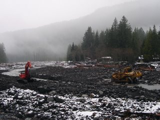
The road to Mt Rainier National Park's recovery is passing through some interesting terrain. Today, I saw a large bulldozer working in the Nisqually River. One of the vexing problems for the NPS is that rivers and streams have jumped their main channels. During a storm, riverbeds can become filled with debris, which in turn causes the river's flow to change its course. To some extent, that is why the Emergency Operations Center was threatened, and why the stream jump at Kautz Creek is causing such a repair headache. So to protect the facilities in Longmire, heavy equipment is now being used to clear the build up of rock, logs and other debris from the last rainstorm and flood.

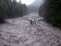
The historian in me wanted to capture a during and after view of the Nisqually River. Here is the "during" image from Monday afternoon, Nov. 6th when things really started to roll. This picture is taken from the Longmire bridge looking upstream.


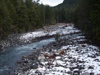
And here is the "after" view, taken today Nov 17th. Note the tree that hangs over the Nisqually River in both photos, and also the color of the river.