The day after I made it to the top of Angels Landing I was at the Visitors Center and saw a poster on sale that showed Walter's Wiggles and Angels Landing, together. A notation stated that it had been taken from the West Rim Trail. Hmm, I wondered if I could find that spot and take my own photo. So a couple of days later, I made that trek for the third time to Scout's Lookout! The trail didn't get any easier either. But, Oh!, the views were well worth the effort.
 Angels Landing from the beginning of the West Rim Trail. Scout's Lookout is in the foreground (that flat, sandy area). The trail ascends that small peak on its west side then climbs up the ridge of the second peak.
 A full view of the east side of Angels Landing showing the 1200 foot sheer drop to the Virgin River flowing through the valley below.
 I followed the West Rim Trail for about an hour when it took a decided turn towards the North. I looked behind me and saw an unmarked trail through the sand leading to a section of slick rock. Venturing off the trail I followed the slick rock to it's end, about half an hour or so. (Photo was taken on my way back, hence the change in lighting.)
 There below me was the scene I was seeking. Walter's Wiggles and Angels Landing. I spent several hours just sitting there at the edge, looking down. It was a wonderful spot to have lunch!
 By mid-afternoon, the sun had almost disappeared, clouds had moved in and the wind had picked up considerably. Reluctantly, I left my perch on the side of the canyon.
On my way back down, I caught a glimpse of the duo from another spot just a little ways off the trail. I had to carefully move down the side of a little “hill” of rock. This angle shows some of Refrigerator Canyon, which you have to go through to get to Walter's Wiggles.
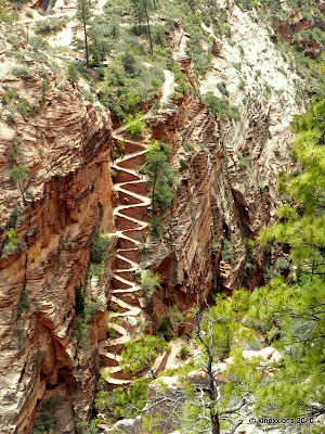 Walter's Wiggles from the first vantage point.
 And from the second viewpoint.
Other posts in this series:
- Angels Landing :: The Prelude
- Angels Landing :: The Overture
- Angels Landing :: Interlude
- Angels Landing :: The Finale


 With a little imagination, I could have been in Provence? Replace poplar with cypress, let the sky deepen its blue. . .


 The caption under this picture in the display reads: “Men of the 9th Indiana, a regiment of Hazen's brigade in the Army of the Ohio, in camp before the battle.”


 Part way up the trail, eyeball to eyeball with Angels Landing (with the help of the 7x zoom). It doesn't look quite so “bad” from this angle.
 After you go up a series of steep switchbacks you enter a narrow canyon that has a stream running through it, but there wasn't much water actually flowing. This was one of the neatest parts of the hike, in my opinion!
 There were pools of standing water but we didn't get our feet wet.
 The sky and the walls of the canyon are reflected in one of the pools of water.
 This was taken on the way back down, entering the canyon from the east.
 The trail has exited Echo Canyon and is progressing up the east side of the canyon wall.
 I'm still going up, but they are going down.
 The destination, Observation Point, is just above the red “lines” in the center.
 This last uphill stretch seemed never-ending.
 Finally, the plateau. But there is still a ways to go to get out to the point.
 Part of the group of 63 kids. A very well-behaved group they were.
 The lower portion of the trail, coming up out of the Zion Canyon floor. The Observation Point trail goes off to the left (top center of photo). The three topmost switchbacks belong to the Hidden Canyon Trail, which goes off to the right.
 The top of Angels Landing ranges from 20 to 40 feet in width. There are people up there...
 As I was promised by my camping neighbors, Maryann and Rob, the view from Observation Point is spectacular. The Virgin River flows through the valley, Angels Landing is in the Center, and then the eastern wall of Refrigerator Canyon. Fantastic.